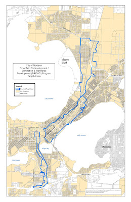
 Ok – so in actually reading the info for the Economic Development Commission Meeting, I discovered that my house and my recently redeveloped office building are both in a brownfield redevelopment area. This was news to me! And even more surprising was the State Capitol and a huge chunk of my residential district that I didn’t expect. Yes, the E Washington Corridor, that makes sense, but it didn’t make sense to include housing that we are trying to preserve or areas that are planning to stay residential. Then again, seems to me that we need to get that Downtown Plan done for the Comprehensive Plan and until it is, we shouldn’t be “target areas” for brownfield redevelopment.
In looking at these maps, it got me to thinking. Um, why hadn’t the Director of Planning and Development (or whatever we call it) and the Office of Business Resources (or whatever we’re calling that now) mentioned any of this to me or sought my opinion? Why hasn’t it been discussed with our neighborhood association? Or mentioned during the discussions of the Tenney-Lapham Neighborhood Plan? How did these maps get drawn in the first place?
If you want a more detailed picture, take a look here for
a – Isthmus
b – South Park Street
c – Packers & Sherman
d – the entire map on the left.
I’m all for getting brownfield redevelopment money and creating jobs, but hey, who said that this current housing was a redevelopment area for jobs? Here’s the proposed requirements (click on the microsoft document) for the program and the resolution the City Council will be asked to pass. I find the “map” issue most disturbing and find it hard for me to think that I want staff to randomly select which areas they think are appropriate after their first go at it.


